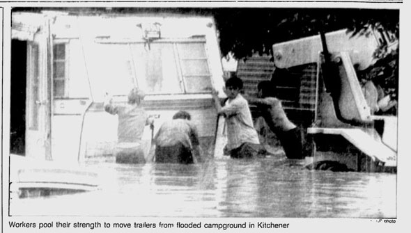
Although legacy of yesterday's storm is still up in the air, the deluge has naturally drawn comparisons to Toronto's other major rain disaster, Hurricane Hazel. The 1954 hurricane and associated flood was, until last night, the biggest rain event the city had ever experienced and is still its deadliest natural disaster.
A perfect storm comprising a high water table, saturated ground, and poor planning caused the sucker punch that lead to widespread changes in the way Toronto was allowed to grow.
Doing what rivers do best, the Humber and Don have all flooded countless times in their long history. In the early days of Toronto, ice jams in the spring thaw were common culprits for submerged rail tracks and washed out roads. As historian Stephen Otto notes, the straightening of the lower portion of the Don may have exacerbated the issue.
The first recorded flood in the region took place in 1797. In 1878, Brampton was inundated by water, causing damage to roads, bridges, and small mills. Early floods repeatedly wiped out the bridge at Winchester Street that led to Kingston and the east. Toronto's assortment of now-buried rivers and streams have also caused damage before they were tamed by engineering.
Here's a rough timeline of Toronto floods, starting with the mother of them all.
HURRICANE HAZEL - OCTOBER 1954
The storm started innocuously as a ridge of low pressure in the Atlantic Ocean, known as a tropical wave, west of the Azores. As storm cells in tropics often do, Hazel intensified into a sizable hurricane that lashed the Caribbean with 160 km/h winds and torrential rain. 1,000 people were killed in Haiti without the eye of the storm ever making landfall.
Hazel struck in the U.S. on 14 October, 1954, packing winds of more than 240 km/h. The force destroyed the coastal town of Garden City, South Carolina, and whirled northward towards Toronto with tremendous speed.
The "roughstorm," Hazel's leading edge, drenched the city, snarled traffic and caused minor floods in road underpasses. The Star estimated 7,000,000,000 gallons of water cascaded from the leaden skies, saturating the ground and raising the water table.
Toronto went to bed on 15 October, 1954 with a forecast of showers before midnight and stiff winds.
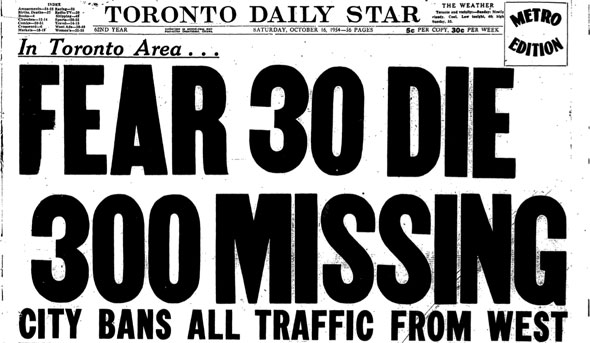
The screaming headlines the next day echoed what everyone already knew - Hurricane Hazel hadn't passed as a benign post-tropical storm, it had scored a direct hit on Toronto, causing serious damage and loss of life.
Five volunteer firefighters were killed when their truck was swept off Humber Blvd. south of Dundas; five children and their mother drowned when the car they were traveling in was dragged from the road by the raging torrents.
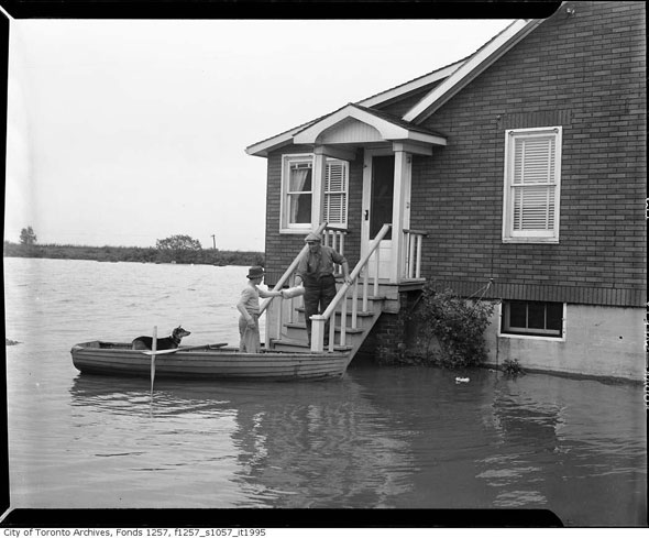
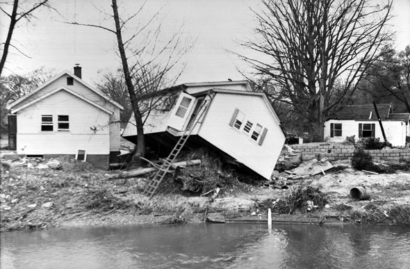
Water rose by 6-8 metres in the Humber Valley, prompting people living close to the river to scramble on to roofs, into trees - anything above the water line. Dramatic photographs showed helicopters plucking people from makeshift islands as the brown water lapped at the eaves of homes.
When the dust settled, 81 people were confirmed dead in Canada. Raymore Drive, a residential street on the floodplain of the Humber, was home to 36 of those killed. Its location close to the water and the positioning of a footbridge that later broke free and acted as a battering ram caused it to be worse hit than other streets.
On Island Road near the 401 a four-month-old baby was left orphaned when her family home was swept away with her parents, Mr. and Mrs. Clifford Thorpe, and two-year-old brother Bobby still inside.
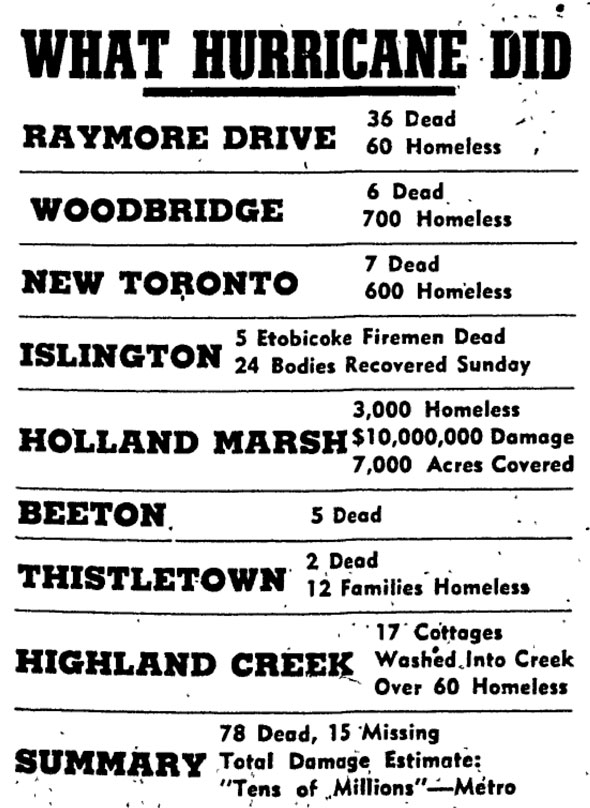
The storm's deadly legacy and $125.2 million in damage led to the creation of the Toronto and Region Conservation Authority and widespread expropriation of flood-prone land. Restrictions on the location of homes and other buildings were implemented and much of the Humber and Don flood plains was preserved as parkland.
A memorial to the victims was built on the former site of Raymore Drive.
BIG RAIN - SEPTEMBER 1986
Two days of persistent, heavy rain over Southern Ontario affected communities from London to Toronto in the mid-80s. 63 mms of rain fell at Pearson over a 24-hour period, adding to a cumulative total that made the summer of '86 the wettest on record since 1928. 371 mms fell in June, July, and August.
Toronto police were forced to close the Don Valley Parkway due to rising water for the third time in as many months as a precaution. Waist deep water was reported in some areas as rivers overflowed.
FISHY BUSINESS - MAY 2000
 A
month's worth of rain fell on Toronto in May, 2000, giving hundreds of
Don River carp the chance to become road kill. 100 km/h winds and heavy
rain flooded the Don Valley, Mimico Creek, and Black Creek River,
dredging fish and all kinds of detritus onto city roads.
A
month's worth of rain fell on Toronto in May, 2000, giving hundreds of
Don River carp the chance to become road kill. 100 km/h winds and heavy
rain flooded the Don Valley, Mimico Creek, and Black Creek River,
dredging fish and all kinds of detritus onto city roads.67.8 mms of rain fell in downtown Toronto, causing 90 power outages, 457 car crashes, 230 calls to fire crews by citizens surprised at the ferocity of the storm (sound familiar?) "We did not issue any flood warnings because we were not expecting so much rain," said flood control engineer Don Healey.
THE "MIRACLE ESCAPE" - AUGUST 2005
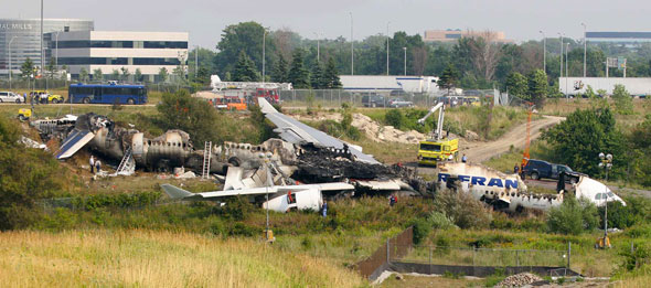
It didn't cause a flood, but this storm did have serious consequences. On 2 August, 2005 Air France flight 358 - an Airbus A340 - was on final approach to Pearson airport. Pilots and air traffic control were reporting thunderstorms and heavy rain in the area.
540 flights had already been cancelled that day. As the flight from Paris lined up to make a landing, the weather worsened significantly and heavy rain lashed the tarmac. The plane touched down halfway along the runway and a miscommunication between the pilots led to a delay in deploying braking mechanisms.
Moments later, the plane and all 309 people on board skated off the end of the runway and dropped down an embankment in to Etobicoke Creek. Miraculously, everybody survived the accident despite the hull being destroyed by fire.
TORNADO OUTBREAK - AUGUST 2005
As F2 tornadoes pounded Milverton, Conestogo Lake, Salem, Lake Bellwood, and areas in between, a powerful line of thunderstorms poured forth on Toronto on 19 August, 2005. At its peak, winds topped 72 km/h and 1,400 lightning strikes were recorded a minute.
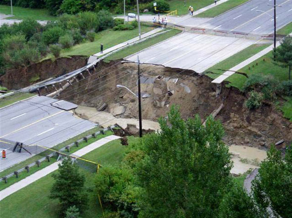
103 mms of rain - 130 mms at Environment Canada's Downsview offices - fell across North York resulting in flash floods that submerged basements, backed up sewage pipes, and washed out roads, including 30 metres of Finch Avenue West.
The most dramatic moment occurred when 4 people had to be plucked from the raging Don River by marine services. 15,000 insurance claims were filed as a result of the storm cluster.
UNION STATION FLOOD - JUNE 2012
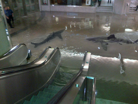
The legacy of last summer's Union Station flood was really all about comically altered photos. A burst of heavy rain caused an overflow of the sewer system that sent a cascade of sewage in to the subway and lower levels of the Front Street property. The water was pumped out quickly and TTC service resumed later that evening.
DON VALLEY FLOOD - MAY 2013
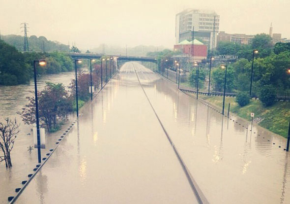
Very similar to last night's weather, 60.2 mms of rain fell in a very short period, flooding the Don River south of Bloor Street, closing the DVP, and shutting down GO's Richmond Hill line (before any trains could get stuck.) The Instagram pictures now look a little tame in comparison.
Please share this
No comments:
Post a Comment